How to make a Town Map
A new map for Morpeth
A while ago I was asked by Morpeth Town Council to reimagine the map which sits in the large display frames around the town. The new map needed to celebrate everything the town has to offer, and to show where the important and interesting places can be found.
Where to begin!
The first job is to talk to the client about the purpose of the map - who it’s for, where it will go, and what it might be needed for in the future. At this point I ask for a long list of places/features and that becomes my starting point. There is invariably some discussion about what should be included and what should be left off. So the Changing Places toilet is very important for visitors to the town but those visitors don’t necessarily need to know where the schools or the recycling centre are located.
I will then visit the town and take photos, make sketches and notes (I am fortunate enough to live in Morpeth so for once this was easy). I will collect as many existing maps as possible, and look at lots of pictures and existing photos.
Then I decide which place will be at the point furthest north, east, south and west, and they become the boundary of the map. I need to bear in mind that no matter what the actual geography looks like on Google Earth, my map needs to be a certain shape eg. square/rectangular portrait/rectangular landscape. In this case the map needed to be almost square in order to fit the existing display frames. There is always a heck of a lot of redrafting and triangulating of places to make sure I am as accurate as possible whilst spacing things out to make them readable, and of course, making it look nice!
The sketch

This is the unglamorous bit, where I figure out how to fit everything in. Really this map should be tall and thin but it needed to fit the existing large wooden frames which are nearly square, so I had to use some artistic license. Navigating the relationship between accuracy and communicating the information necessary is one of my favourite challenges (no, really it is!). I always need to stick extra bits of paper on, there is a lot of rubbing out and it all looks pretty ugly at this point.
The pencil drawing

Once the geographical composition has been approved (with a photo to the client and some revisions) I can begin what I call the “proper” pencil drawing. This is on the larger piece of watercolour paper which will become the finished original. I use a soft 2B pencil and try not to press too hard, as there is just as much rubbing out at this stage. You might be able to see the faint lines I used as a grid, to help me copy the smaller sketch onto the larger paper. I decided to do away with the current long list down the side and the complicated key, so all of the features needed to be labelled in a way that looks good but doesn’t obscure anything important. Another nice challenge!
The ink drawing

Once everyone is happy with the pencil drawing, I do it all again with black waterproof ink. I love the smooth, even lines you get with fineliner pens, and prefer to use “hot press” watercolour paper, which has the smoothest surface. Once the ink is on, I can rub out all of the pencil lines and send another photo to the client for any final tweaks. Then I can stretch the paper onto my wooden board, ready to add some colour (my favourite bit).
The painting
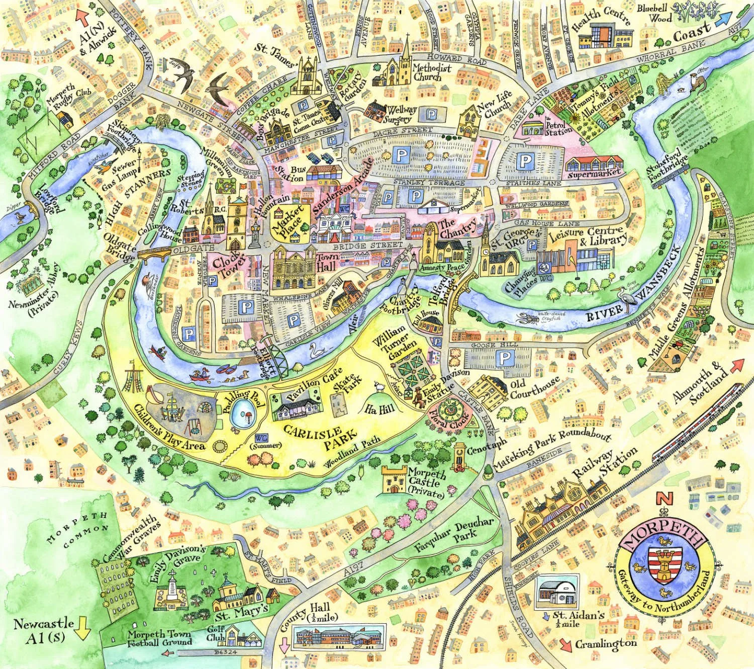
Here’s the final painting. I knew I wanted it to be eye-catching, so I employed my full arsenal of colours. Knowing that your work will be publicly displayed is nerve-wracking as it’s difficult to predict how something will look after it’s been printed. For my own prints I can have proofs done and make adjustments, but when you hand your work over to a large organization they have control. Anyway, I was very happy when I saw it. Phew!
It’s a huge map so here are a couple of details:


The map in situ

One wet Friday morning I was lucky enough to see the map unveiled (removed from its binbag!) in the market square, along with the leader of Northumberland County Council, Morpeth Town Mayor and the Mayor’s Consort. Don’t tell anyone but I must admit to feeling quite proud.